The building of Lakewood broke records and made Lakewood the talk of the nation. Empty fields became 17,500 houses in less than three years
As American forces gathered in 1944 for the final assaults on Germany and Japan, GIs were given War Department booklets that discussed postwar housing needs and gave advice on how communities could avoid the defects that had characterized worker housing in the first half of the 20th century.

Veterans celebrate Memorial Day in Lakewood Village in 1949
By the war’s end in the summer of 1945, more Americans were more informed about national housing needs than at any time in the nation’s history.
Americans formed a rough consensus on what that housing should look like, based on the hopes of men and women who had gone through the harsh years of the Depression and the privations of wartime. They had few illusions about the responsibilities of homeownership, but they were willing to take them on,
This consensus also reflected the decisions made by government agencies and business leaders who decided not to build the modernist housing favored by many architects or the public housing urged by urban planners. What mortgage lenders and the construction industry favored – single-family homes in a conventional style – looked exactly like Lakewood would in 1950.
In early February 1950, the Lakewood Park Corporation broke ground on 3,450 acres of farmland, transforming the Montana Ranch into what was then the nation’s largest planned community. The first house foundations were poured on February 24. (A closer look at Lakewood before construction began)
Heralded as “the city they built in six months,” a new house was completed every 7 1/2 minutes, 40 to 60 houses per day, with a record 110 completed in a single day. According to one newspaper account, “each hour sees new homes completed. 1500, about $13,500,000 worth, have been sold in the short space of five weeks.”
In 2003, Ruth Smith described her disbelief as she watched Lakewood go from “just bean fields” to a complete community, “All these little houses had sprung up like mushrooms,” Smith told Lakewood’s CityTV. “I couldn’t believe it; it was just like The Wizard of Oz. I mean, it was just astonishing ... up one street and down the other were all these framed houses going up. It was really like seeing a fairy tale take shape in front of your eyes. You just couldn’t believe it went up that fast. Then all of a sudden, the grass grew, the trees were planted, and here you were.”
The Lakewood Park project was so large that two construction firms had joined with Los Angeles businessman Ben Weingart to develop the Montana Ranch. The Lakewood Park Corporation was an alliance of Aetna Construction (Louis Boyar), Biltmore Homes (S. Mark Taper), and Weingart. Boyar and Taper were experienced developers in Los Angeles and Orange counties. Weingart was well-connected in financial circles in Los Angeles and he also was a major property owner.
 A fleet of trucks equipped with a conveyor belt lifted bundles of shingles to workmen waiting above.
The new company was headed by Boyar as president and Taper as vice president. Behind the scenes, but very much involved, was Weingart. Backing him was the Prudential Insurance Company’s real estate division.
Prudential had agreed to loan the Lakewood Park Corporation $8.8 million to buy the Montana Ranch, its water rights and wells, and the Lakewood golf course and clubhouse.
Louis Boyar (known as Lou) was born in San Francisco in 1898. His wife is supposed to have saved and borrowed the $700 that her husband needed to start his own construction company in the 1930s.
After the success of Lakewood Park, Boyar built more suburban homes, primarily in the San Fernando Valley. He also was committed to the cause of Israel and was especially active in the Bonds for Israel organization. He was a benefactor of the Hebrew University in Jerusalem, founding its Mt. Scopus campus and financing the construction of the Harry S. Truman Center for the Advancement of Peace.
 Louis Boyar, 1952
In memory of his wife Mae, who had suffered from arthritis most of her life, Boyar established arthritis clinics in Israel and funded a number of schools, parks, and social service centers in her name, including Mae Boyar High School in Jerusalem.
Boyar contributed to the building fund of the city’s first synagogue and joined with Taper and Weingart in donating the Lakewood Park sales office to the new congregation as a Jewish community center.
Boyar died in Los Angeles in 1976 at age 79.
S. Mark Taper was born in Poland in 1901 and raised in London. He immigrated to California in 1939. In his early years, Taper pursued a number of jobs: teacher at age 13 when older teachers left to fight in World War I, manager at age 16 of his father’s factory after his father was wounded in a German Zeppelin raid on London, shoe store owner at age 19, and eventually owner of a chain of shoe stores at age 25. He then launched a second career building government-subsidized housing in England.
When he moved to Southern California, he had intended to retire, but instead he returned to home construction to meet the wartime housing shortage. In 1941, Taper secured one of the first federal priority orders to build homes for war workers.
Taper’s Biltmore Homes eventually built houses in Norwalk, Long Beach, Compton, and Seal Beach before joining Boyar and Weingart in the Lakewood Park project.
Like Boyar, Taper also was active in philanthropy. Taper financed the escape of Jewish children and other child refugees from Nazi Germany. His many contributions to Los Angeles in later years included a gift of $1.5 million to the Music Center to build the Mark Taper Forum theater.
 S. Mark Taper, 1955
His associates characterized Taper as an astute businessman who worked 18-hour days. Lakewood Park sales manager Woody Smith recounted the time he discovered a distinguished looking stranger going through the company’s files. Startled by the intrusion, Smith wanted to know what the man was doing. He answered, “I’m Mark Taper.”
Taper died in 1994, shortly before his 93rd birthday.
Ben Weingart, who characterized himself as “a lifelong idea man,” was the most colorful of the three developers. “Never worry about losing a deal,” he advised. “There’s always another one around the corner.” When he told his business associates in 1949 that the deal he wanted was to build a city, Weingart said “they thought I had lost my mind.”
Born in 1888 in Atlanta, Georgia and orphaned before he was six, Weingart was raised by a foster family, dropped out of school in the third grade, and worked a series of odd jobs, including picking cotton, hauling water, and driving a laundry wagon. When he was 17, Weingart worked as the advance man for a phony eye doctor. He made his way to Los Angeles in 1906 where he found work running a laundry service for hotels. Weingart leveraged his modest capital to purchase the laundry business. Later, he bought the hotels he delivered laundry to.
 Ben Weingart, 1951
Ben Weingart was responsible for financing the Lakewood Park project. Not only did he secure the initial loan from Prudential Insurance to buy the Montana Ranch in 1949, but he also persuaded Investors Diversified Services of Minneapolis (the nation's sixth largest source of mortgage financing) to manage nearly $250 million in mortgages for the houses that Weingart planned to build.
Weingart turned to Prudential again for another $8 million to begin construction of the Lakewood shopping center in 1950. (When Lakewood was done, he and Boyar bought the 900-acre Platt Ranch and built Canoga Park.)
Shunning publicity, Weingart remained mostly anonymous in his philanthropy. His largest contribution was $2 million and the donation of a hotel on skid row in Los Angeles to house a service center for homeless men. In Lakewood, gifts from his foundation constructed a community center, a senior citizens center, a library, and a YMCA.
When he died in 1980 at age 92, his obituary described Weingart as “one of the least-known and most influential members of the Los Angeles financial community for half a century,” noting that he had been developer of the Fed-Mart chain of discount stores and Los Angeles County’s largest property tax payer as the owner of 42,000 rental units.
The three partners in the Lakewood Park Corporation represented a new breed of builder in the postwar period – the merchant builder who put up complete communities using economies of scale and the latest in construction technologies to mass produce houses.
Other developers (notably Aldon Construction, which built homes in the Lakewood Plaza tract) were building tract house neighborhoods at the same time as the Lakewood Park Corporation, although these developments were not as large.
Efficiency learned in war production drove the pace of construction. Bucket trenchers dug one foundation trench every 15 minutes. Cement trucks in a mile-long line waited to pour the foundations when the wood forms were finished. Pre-cut and pre-fabricated building materials were delivered in exact amounts directly from the subcontractor to each house site.
4,000 construction workers divided into 30 work units, including 19 just for different carpentry tasks, formed an assembly line that moved up one side of a street of house lots and down the other side.
Floor joists were installed by two-man teams that did nothing else. One man with a pneumatic hammer nailed the subflooring for five houses each day. Carpenters used power door-hanging machines. A conveyor belt on the backs of specially-built trucks lifted bundles of shingles to roofs. A fleet of other trucks delivered 200,000 doors.
 Every kitchen was equipped with a "pulverator" under the sink.
Expediters directed the vast project using two-way radios, and foremen barked orders to the teams of workers from a loudspeaker truck. Inspectors from the Veterans Administration kept watch on the quality of construction.
Lakewood Park homes came in 52 slightly different combinations of trim and siding. The houses were designed by Paul J. Duncan, the former assistant chief architect in the Federal Housing Administration's Los Angeles office. The builders kept identical designs separated, mindful of the stories told of Levittown residents mistakenly wandering into the wrong house. In Levittown, all the houses were nearly the same.
Taper told reporters, "It is our aim to provide a good quality home for any man who has a job: the one who earns $200 a month as well as the one who earns $400."
By the start of 1951, almost 8,000 homes had been completed. In one amazing week, work had started on 567 homes. By the end of 1952, 14,000 homes had been built and sold with another 3,500 planned for 1953. (Lakewood Park was advertised almost daily in the Long Beach Press Telegram and Los Angeles Times.)
The pace of development was fantastic, but critics predicted that the speed of construction would condemn the community to slum status. A community that had gone up that fast, they reasoned, must be shoddily constructed. Time would prove how mistaken the critics were.
The critics also reprinted photographs of Lakewood under construction to emphasize what they called the monotony of Lakewood’s gridded streets. In fact, the site dictated a grid plan, since the new community was built on a flood plain and curving streets would have impeded the flow of runoff.
 Lakewood homes were built on an assembly line basis.
"Living in beautiful Lakewood is more than owning a home ... it is a new and better way of living," one Lakewood Park advertisement from 1950 proclaimed. Better, of course, is relative. At least, a Lakewood home wasn’t an oil worker dormitory in Bakersfield, a four-room tenement shared with parents and siblings in a Midwestern county seat, a Quonset hut on the outskirts of a factory town, or a shack at the end of unpaved road somewhere in the rural South.
Those were some of places the residents of Lakewood had known before they arrived in 1950. Compared to those places, Lakewood did offer a “better way."
Called a “$250 Million Planned Community” in news accounts and sales brochures, Lakewood Park was more than rows of houses. The project featured sites for schools, parks, and places of worship, along with 16 neighborhood shopping centers. These amenities were generally located within a half-mile of homes in each tract so that even those who did not have a car could enjoy the benefits of suburban life. (A closer look at the many parts of Lakewood)
The plan also included parkway panels and service roads separating residential areas from major thoroughfares – an idea that was said to come from Boyar’s wife Mae, who remembered the dangers of city traffic when she was growing up in Chicago.
(Another version of the this story has Mae Boyar insisting that the streets be well lighted – even though street lighting was not required by the county – because the lights would make streets safer for children.)
 Mae Boyar wanted to make the new community safer for children.
Both the Los Angeles County Regional Planning Commission and Engineering Service Corporation (ESCO) played a significant role in the design of Lakewood.
In a 1969 meeting to discuss Lakewood's history, Mark Taper noted ESCO's importance to Lakewood's overall design. “They handled all the engineering for us from beginning to end … grading, lots, topography. Everything to the point of improvement of streets …" Taper also credited ESCO with the idea of setting aside sites for neighborhood shopping centers throughout the community.
At the heart of the new development was Lakewood Center, among the earliest regional shopping centers and the nation’s largest by 1954. Lakewood Center had a model to go by. Northgate, a smaller shopping mall but looking much like Lakewood Center, had opened in 1950 north of downtown Seattle. Like Lakewood Center, Northgate’s stores were arranged in two rows facing each other across a walkway that was open to the sky.
The Getty Museum in 2013 showcased the development of Lakewood in Overdrive: LA Constructs the Future.
John Todd recalled that Boyar had invited Lakewood Taxpayers Association officers to a dinner at the Lakewood Country Club in 1949 to announce his plans for Lakewood Park, “At that meeting … Lou Boyar pointed out that they would build a shopping center and around that a city … (and) he would make a city for us and millions for himself. I am glad that he did so.”
Those millions were the subject of a Senate banking committee hearing based on allegations that Lakewood’s developers had manipulated a federal loan program to make huge profits.
The issue was the use of Section 213 of the National Housing Act to build and sell Lakewood Park Mutual Homes in 1951. Unlike conventional FHA financing, which provided a loan guarantee up to 90 percent of the builder's costs, Section 213 gave a 100 percent guarantee.
 The Lakewood Park Mutual Homes tract was successful but also controversial.
Section 213 was supposed to assist nonprofit cooperatives in building homes for the members of the cooperative. Under Section 213, a building cooperative could apply for a federal loan guarantee to buy land and construct houses. Once the houses were built, the cooperative dissolved, and the homes went into conventional escrow for their new owners.
When credit restrictions were imposed at the start of the Korean War in mid-1950, and banks limited the supply of construction and home loans, Lakewood’s developers, with the encouragement of federal housing officials in Los Angeles, used the provisions of Section 213 to build homes that are still called the "Lakewood Mutuals."
The developers began by enlisting their own employees in more than 30 dummy cooperatives to apply for a Section 213 construction loan guarantee. With federal backing, the cooperatives bought land from the Lakewood Park Corporation, hired the Lakewood Park Corporation to build the houses, and used the Lakewood Park Corporation to advertise for buyers who would purchase their house from the cooperative.
Investors Diversified Services – the builders' business partner – managed escrow accounts and made a substantial profit on each one.

Lakewood Park Mutual Homes promised security.
When Ben Weingart and Louis Boyar were subpoenaed to testify before the Senate banking committee, Ben Weingart admitted that he had been a director of as many as 300 companies, but he claimed to know little about their operation. By then, the companies Weingart controlled had managed at least $112 million in federally guaranteed construction loans.
Although the hearings failed to disclose any actual wrongdoing , the hearings did reveal that Lakewood’s developers and Investors Diversified Services actually risked very little of their own money – about $315,000 (of which $300,000 came from IDS and only $15,000 from Weingart, Taper, and Boyar).
Because the three developers worked through so many companies, it’s difficult to know exactly how the three men profited. In newspaper accounts, they are said to have made at least $12 million (equivalent to more than $140 million in 2025).
A story is told how the partnership of Weingart, Boyar, and Taper ended. Three major assets remained to the Lakewood Park Corporation in 1955 – the Lakewood golf course, 16 retail centers located at Lakewood’s major intersections, and Lakewood Center. John Poag, a young Weingart employee, was told to write the name of each of the company’s three assets on a piece of paper and to put the three pieces of paper in Weingart’s hat. As Poag held the hat high above his head, each of the partners pulled out his share of the company.
Taper got the golf course, which he later sold to the county employees retirement fund for almost $5.5 million. Boyar got the 16 retail corners. Weingart got Lakewood Center.
Unlike some other early shopping centers, Lakewood Center was fully integrated into the development of Lakewood. The shopping center’s location placed it in an unusually advantageous position. Surveys showed that nearly 25 percent of consumers in Los Angeles County were located within a 30-minute driving radius from Lakewood.
Ben Weingart later explained, “(Lakewood Center) was all based on the motorcar. I could see it was going to kill a lot of businesses and make others. . . The old shopping pattern – the downtown business districts of most cities – was going to have trouble because people wanted to go there in their cars, and there was nowhere to park. I had a notion of doing something about that and about the housing shortage at the same time.”
 The May Company (architect's rendering, 1949)
Not everyone was ready for the future of retailing. Lakewood Center manager Joe Eichenbaum told a reporter from the Long Beach Press-Telegram in 1972 what happened when he and Ben Weingart came out to look over the shopping center site in early 1949. As they stood at the corner of Lakewood and Del Amo boulevards, a farmer emerged from his house, leveled a shotgun at the two men, and blasted away. “Fortunately he was either too far away or too poor a shot to hit us,” Eichenbaum said.
Lakewood Center was designed by the Los Angeles architectural firm of Albert C. Martin and Associates (with additional contributions from Skidmore, Owings, and Merrill).
The center had a deep setback of 300 feet from Lakewood Boulevard and was graded to slope down from the boulevard to about four feet below street level. That was so drivers would see the huge May Company building rather than a sea of parked cars. A local newspaper reported that the depressed parking lot made the May Company store stand out “like the screen in a drive-in movie theater.” That was precisely the intended effect.
Lakewood Center had more than 10,000 parking spaces (expandable to 12,000) with a ratio of 2 1/2 square feet of parking space for every square foot of retail space. Perhaps too futuristic was a control tower on the May Company roof so that a spotter could direct cars to available parking spaces through a system of colored signals. The system wasn’t a success.
At first, naysayers questioned the wisdom of devoting so much of the shopping center to the automobile, since an earlier auto-oriented center – Shopper’s World in Framingham, Massachusetts – had gone through a difficult bankruptcy in its early years, causing chain stores to be wary of auto-oriented centers.
So real was the concern that the county's Regional Planning Commission required that the center’s parking lots be laid out as gridded streets, so that if the shopping center failed, the site could be turned into a traditional downtown.
Eichenbaum recalled that the idea of a suburban shopping center was so new that many retailers didn’t want to invest in it. “Retailers,” he said, “feared tougher competition in a mall. No one wanted to come in first because it was so new.” Department store companies also feared taking business from their profitable downtown locations.
But Eichenbaum scored a major success. He persuaded the May family to gamble on locating a May Company department store in Lakewood Center even before first homes in Lakewood Park were sold.
 Joseph Eichenbaum (left) and Tom May of the May Company discuss Lakewood Center's growth.
When the May Company chain signed a $3.5 million ground lease in 1950 to build what was called the largest suburban department store in the nation, the Los Angeles Mirror noted that this was “considered one of the most daring steps ever taken in branch retailing.”
Ground was broken for the May Company on October 14, 1950, just one day after the last crop of lima beans had been harvested from the fields around the site. Tom May, executive vice president of the May Company, walked from the speaker's platform to the side of a huge power shovel, turned a spadeful of earth, and signaled the operator to begin digging.
The May Company’s decision to build in Lakewood allowed the Lakewood Park Corporation to secure another $8 million in financing from Prudential Insurance Company to continue construction of the shopping mall. Other stores followed May Company’s lead in 1950 and 1951, often establishing their first suburban branches in Lakewood Center.
The May Company lease included a provision that prevented other major department stores from locating in Lakewood Center for almost 20 years. Because of the May Company’s exclusive agreement, the center featured junior department stores on either end of the mall with the May Company in the center. The first junior department stores were Butler Brothers and W.T. Grant.
The first store to open in Lakewood Center was Butler Brothers on November 8, 1951. 44,000 shoppers streamed through on opening day. So great was the crush that 28 lost children were collected at the store's security office. Hiram’s supermarket, a car wash, and an 18-pump Standard service station also opened.
Although Lakewood Center was planned with the automobile in mind, it was specifically designed to appeal to pedestrian shoppers once they got out of their car. The first phase of the center featured a quarter-mile-long, open-air, pedestrian walkway shaded by fifteen-foot overhangs projecting from the storefronts on either side. Semitropical landscaping and piped-in music provided a relaxing ambiance. The landscaped walkway eventually extended the entire half-mile length of the mall.
 The tunnel under Lakewood Center kept deliveries out of sight and made possible the pedestrian mall between the rows of shops.
Lakewood Center also featured a half-mile-long tunnel under the mall that allowed truck deliveries to be made directly to each store’s basement area, freeing ground floors for sales and displays and separating truck traffic from automobile traffic.
The tunnel, with its three-foot-thick concrete walls reinforced with 805 tons of steel, was designated as a Civil Defense fallout shelter, capable of holding 6,000 people in the event of a nuclear attack.
In September 1961 during the Cuban missile crisis, the city newsletter devoted nearly the entire issue to civil defense planning and the presumed safety of the mall’s tunnel.
The opening of the May Company department store on February 18, 1952 filled every available parking space at Lakewood Center and brought 200,000 customers crowding into the store during the following weeks.
At 345,000 square feet, the Lakewood May Company was the largest suburban department store in the country. The building was a windowless, rectangular concrete box in the International Style topped with four, 16-foot-high Ms that lit up in yellow neon at night so brightly that the Ms could be seen for miles.
“I remember that when we would go to San Pedro to visit the relatives, we could see the big M for miles around,” recalled long-time resident Linda Kay Gahan in 2003. “That was really a big thing, because you could say, ‘Well, I live near the big M for May Company.’ It was very, very impressive.”
 The groundbreaking for the May Co. in 1950 marked the start of California's first regional shopping center.
Inside, the four-level store featured a tearoom, a small clinic with nurses on duty at all times (and a physician at certain hours), and an auditorium available to Lakewood organizations for meetings.
Each department was decorated in its own color scheme to complement the merchandise. Among the departments was “the West’s largest youth department … planned deliberately on the basis of the vast number of children in this family community.”
Promoted as “the 154-acre ‘shopping heart’ of Lakewood” (260 acres if the parking lot acreage was included), Lakewood Center was nearly a city in itself, or as Joe Eichenbaum called it, a “shopping city.”
In addition to commercial tenants, Lakewood Center eventually included office buildings, a 250-bed hospital, a county library, a post office, banks, a bowling alley, county offices, and Lakewood’s first city hall. It also included an automobile service center, a bowling center, a garden center, restaurants, and supermarkets.
By 1954, Lakewood Center was so big that a free shuttle transported shoppers between the mall and the adjacent Faculty Shops, a block-long row of specialty shops next to Faculty Avenue.
The Faculty Shops were aimed at local businesses and smaller chain retailers. Among the 36 stores were an Orange Julius lunch counter, Taylor’s Quality Meats, Ranger’s Chow Mein to Take Out, Choats Famous Do-Nuts, Jacqman Paints and Wallpaper, Lakewood Center Stationers, Sav-On Family Shoes, Lakewood Center Tastee Freeze, and De Cannis Hair Styling.
The Faculty Shops were eventually demolished to enable the building of a Bullock’s department store. In 1993, Bullocks closed after 29 years in Lakewood Center. The building was demolished in 1995 to make way for a Home Depot and a supermarket.
 The four giant Ms on the top of the May Co. were a beacon for shoppers.
Lakewood Center also was Lakewood’s community hub. The Lakewood Center Businessmen’s Association (LBCA) sponsored Easter egg hunts, annual visits from Santa Claus, Dollar Days (during which a helicopter dropped pie plates, redeemable at Boys’ or Hiram’s markets for a frozen fruit pie), Mother’s Day gift drawings, Halloween carnivals featuring television celebrities, and teen dances (for which the LCBA donated records as prizes).
Linda Kay Gahan, whose first job was working at Butler Brothers department store, recalled her visits to Lakewood Center as a child: “One of the first things I remember is my grandmother taking a stroller with my sister in it, and we walked down to Lakewood Center to watch them build it ... I also remember polio vaccines ... We would all line up at the mall to take the sugar cube.”
Lakewood Center also was a point of pride for Lakewood’s residents, as Dennis Lander recalled, “I remember my parents would talk to other relatives and that would be kind of a bragging point ... we live in Lakewood and by the way, we have the largest shopping center in the world.”
In 1961, the center became the birthplace of another trend – corporate headquarters locating in shopping centers – when the Purex Corporation moved its international headquarters there.
Lakewood Center’s development took off between 1964 to1965, when Buffums, Bullocks, and Desmond’s department stores opened, followed by JC Penney’s opening in 1967 to anchor of the southern wing of the mall. That year, Lakewood Center became one of the first shopping centers to in the nation to feature motion-picture entertainment with the opening of the Lakewood Center Theatre, a 1,200-seat Cinerama theater.
See Lakewood Center grow in this collection of historical photographs.
Today, Lakewood Center remains one of largest regional shopping centers in Southern California and one of the busiest. More than 60 years after the center’s first stores opened, “shop Lakewood” is still good advice for value, quality, and convenience.
In 1944, a team of Los Angeles County map makers examined aerial photographs of what is now Lakewood and drew what they saw in amazing detail. Their hand-colored map is a snapshot of a mostly rural landscape poised for future growth. But in 1944, the focus was on winning a war. Building new homes, schools, and a shopping center would have to wait another six years until the Lakewood Park Corporation purchased the empty acres shaded in green on the map and began building the nation’s largest planned community.
The map makers in 1944 labeled hay and alfalfa fields, dairies, hog farms, and a few orchards and some crop land. They noted the military presence around the vital Douglas Aircraft plant. They also identified the scattered homes of farmworkers and the barns and offices of the Montana Ranch on Arbor Road.
Open ditches skirt Carson Street and cut through what will be Mayfair Park. Missing from this map are the Mayfair housing tract north of South Street and the portions of the Montana Ranch that extended to Cherry Avenue.
In the center of the map in yellow is Lakewood Village. To the right in yellow is the almost forgotten Lakewood City tract (above and below Carson Street).
Left of the village and adjacent to the Lakewood Golf Course are yellow rectangles on Annapolis Road and Lakewood Drive. There are just eight of them – the houses of Clark Bonner’s dream of the Lakewood Country Club Estates.
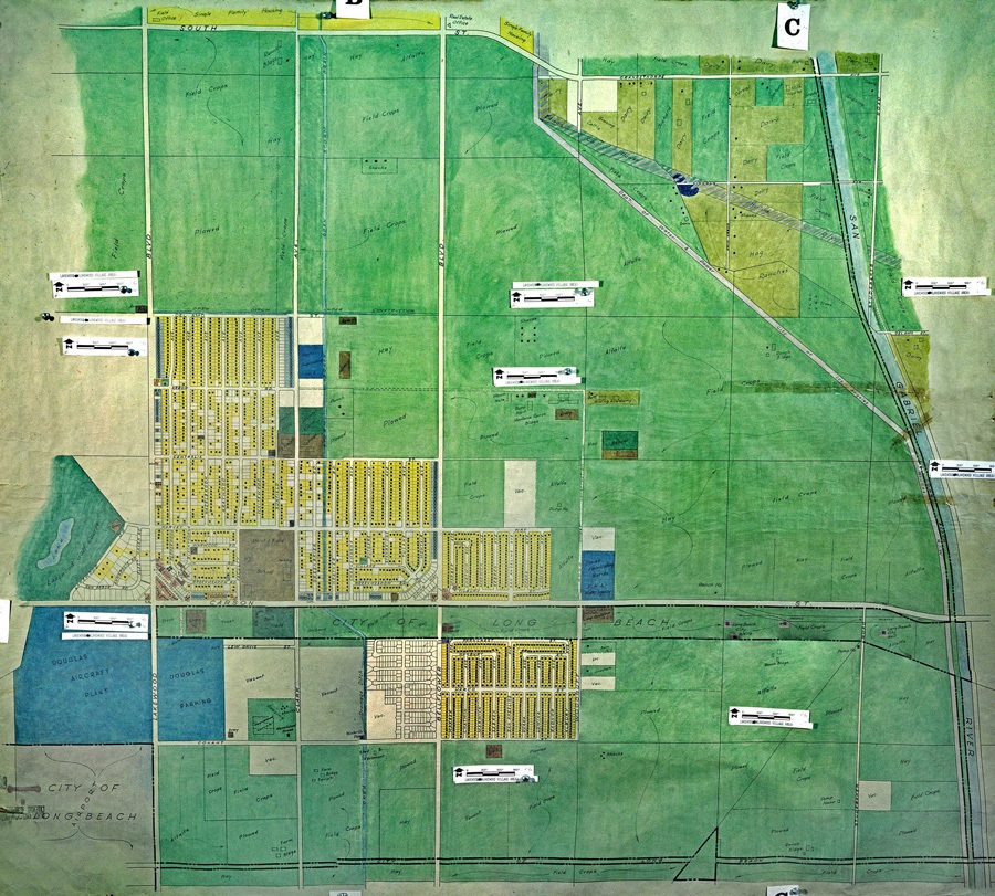
Source: Los Angeles County Regional Planning Commission land use map of Lakewood, 1944, call number: LACoPRC Lakewood 01, The Huntington Library.
In the Sunday, July 16, 1950 edition of the Long Beach Independent Press-Telegram, a wide-eyed reporter described the building of Lakewood Park:
Utilizing construction “know-how” in combination with economies in working methods and handling of materials, Lakewood Park is producing two-bedroom and three-bedroom homes at prices from $7825. Ex-GI buyers make no down payment. Their terms are from $43 monthly, including principle and interest, taxes and insurance.
One of the secrets of the whole Lakewood Park operation, the schedule was blueprinted in tight time charts long before ground was broken for the first foundation.
 Cement crew laying sidewalks in 1950
“We drew up building sequences so that construction gangs would have the smallest amount of moving between one job and the next,” Lakewood Park officials declared yesterday. “This means that building generally proceeds up one side of a street and down the other.”
As a construction crew moves up a street, supply trucks dump the required amount of timber, doors and pipes on the lots ahead, with the material coming directly from the supplier.
Foundations are dug, concrete is poured, underplumblng is installed, lumber delivered, subfloors … raising rafters … sheathing … shingling. All come in sequence.
Spectacular is the operation in which red cedar shingles are hoisted up onto the rafter skeleton roofs by special electric belt conveyors from a huge aluminum-enclosed truck.
Sidewalk superintendents are especially fond of watching the automatic nailer which enables one workman to secure subflooring on eight houses a day.
Strapped to his foot and operated by a button on its cane-like handle, the automatic nailer and its operator move haltingly back and forth along the subflooring. The workman takes a step, steps, presses a button – and rat-tat-tat – in goes the nail in machine-gun-like rapidity.
Lakewood Park construction officials say 75 houses are done at each operation. That means workmen lay the foundations for 75 units per day and move on to another 75 the next. Meanwhile, another crew comes along and installs the underground and underfloor plumbing on the first 75. Following the plumbers the joists are installed.
This crew is followed by about 28 others, with regular inspection by government agencies until the houses are ready for occupancy.
Use is made of mechanization wherever possible. Aside from such aids as power saws, the automatic nailer and the shingle belt lift, there are radial-arm power saws, powered door hanging machines and (chain) diggers which can excavate a house foundation in 15 minutes. Curbs are laid by a traveling mixer which pours liquid concrete into a curb frame along the 266 miles of curbing in Lakewood Park.
 Raising house frames in 1951
When completed, Lakewood Park houses include the following features: A garbage disposer, double sinks, stainless steel drain boards, painted walls, shades and screens. Kitchens have inlaid linoleum and bathrooms are equipped with rubber tile. All homes have garages. Gardens are dug over and a tree is planted in front of each dwelling.
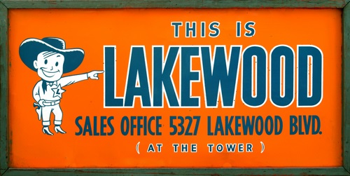
Nine completely furnished model homes are open to 10 p. m. dally near the Lakewood Park sales office, 5327 Lakewood Blvd.
Tract names have given character to Lakewood neighborhoods since the earliest days of the city’s development. Mayfair, the Mutuals, Imperial Estates, and Cherry Cove are only a few of the names that brought new neighbors together.
Much of Lakewood was developed as tracts with hundreds—sometimes thousands—of new home, but many smaller tracts also make up the fabric of the Lakewood community. This roster includes the largest of the city’s neighborhoods, but every neighborhood is essential to the Lakewood story. Each has its own unique aspects and history.
Lakewood Village was the name chosen for the Montana Land Company’s original development in 1933, probably a reference to a fashionable, 19th century resort in New Jersey. After the sale of the company in 1949, the Lakewood Park Corporation added "The Future City as New as Tomorrow.” Maps showed its boundaries from South Street to Carson Boulevard and from Bellflower Boulevard to what is now Downey Avenue.
These streets were south of an existing neighborhood named Mayfair by its developer Charles Hopper. (Mayfair refers to a district of London noted for its stately townhouses.) Mayfair was informally called Radio Park because many of its streets were named after early broadcast stars, with streets such as Autry, Fidler and Hersholt. On the opening day of the Mayfair development, Hopper gathered several radio stars for a ribbon cutting, including Gene Autry, Hedda Hopper and Jimmie Fidler.
The Mayfair neighborhood extends from Ashworth Street to South Street and from Lakewood Boulevard to Woodruff Avenue. Mayfair Park, at Clark Avenue and South Street, was once Lakewood’s only park.
 Lakewood City was one of several wartime developments promoted by the Montana Land Company.
A smaller neighborhood – called Lakewood Gardens – was begun west of Lakewood Boulevard by developer Paul Trousdale in 1946. (Trousdale later became famous for developing the Trousdale Estates in Beverly Hills.) He built slightly less than 500 homes from Lakewood Boulevard to Hayter Avenue and from Ashworth Street to South Street. The development included a clubhouse and pool for the homeowner's association members. Lakewood Gardens is home to one of the oldest homeowner associations in California.
Facing the Lakewood Golf Course on Lakewood Drive are homes in the original Lakewood Country Club Estates. Intended to be a suburban retreat for wealthy homeowners, very few homes were built in the Estates during the first phase of development because of the economic effects of the Great Depression. Most homes in the Country Club area were built between 1936 and 1960.
East on Carson Street, past the Lakewood Village section of Long Beach, is a piece of what was once called the Lakewood City tract. These homes, east of Bellflower Boulevard, were built by developers Griffith & Legg in 1942.
Three phases of development
The Montana Land Company sold 3,300 acres of its Montana Ranch property to the Lakewood Park Corporation in 1949, which proceeded to build 17,500 Lakewood homes in three phases between 1950 and 1953: Lakewood Park, begun in 1950 east of Lakewood Boulevard; Lakewood Mutual Homes, begun in late 1951 west of the boulevard; and Carson Park, begun in 1952 and located east of Palo Verde Avenue. Lakewood Park was the largest of the three phases and included the development of the Lakewood Center shopping mall. As the building of Lakewood Park homes moved east, the neighborhood south of Arbor Road between Bellflower Boulevard and Woodruff Avenue was given the name Briarcrest.
Lakewood Mutual Homes, east of Lakewood Boulevard, were built under credit restrictions imposed at the start of the Korean War in 1951. To avoid the credit crunch, the developers turned to a Depression-era arrangement that guaranteed loans to non-profit home building cooperatives.
The homes in Carson Park, east of Palo Verde Avenue, were built in 1952 and 1953 under the same financing plan as the Mutuals. Today, the neighborhood is home to Monte Verde Park and the San Gabriel River Parkway Nature Trail. The part of Carson Park north of Carson Street became Lakewood in 1954, but most of the neighborhood south of Carson Street (separated from the rest of Lakewood by Heartwell Park) had voted to become part of Long Beach in 1953.
Eastern Lakewood
When the city incorporated in 1954, the area east of the San Gabriel River was still unincorporated and not part of Lakewood. Some of what is now eastern Lakewood was still farms and dairies and a few homes built in the 1930s.
The Lakewood Park Corporation developed most of the western part of the city in a uniform fashion, so that today these neighborhoods still look much the same. Eastern neighborhoods were built by smaller developers, mainly between 1957 and 1963. These neighborhoods—which cluster around Artesia High School, Bloomfield Park and Palms Park—were approved by the Los Angeles County Planning Department, and each developer was free to choose designs that were different from neighborhoods nearby and from neighborhoods in western Lakewood.
The residents of these eastern neighborhoods petitioned the Lakewood City Council in 1961 and 1962 to make their neighborhoods part of the new city of Lakewood. Majorities of voters in each neighborhood voted for annexation. All of them had become part of Lakewood by 1963.
Ed Krist’s “Happy Homes” along Pioneer Boulevard is one of the small tracts of eastern Lakewood. Several streets of houses in a modern style were designed in 1953 to be affordable for first-time homebuyers. Their unique features—flat roofs and carports—stand out from the surrounding neighborhoods.
One of the larger builders in eastern Lakewood was Emblem Homes. The company built two Imperial Estates tracts clustered around Aloha Elementary School and Palms Park between 1958 and 1962.
La Mirada Homes developed the area west of the 605 Freeway as Sunshine Homes between 1961 and 1963.
Lakewood Shores, built in 1977, is a gated community of townhomes on Centralia Avenue at the far eastern edge of the city.
Many developers
Neighborhoods west of the San Gabriel River were added to a growing Lakewood as well. Lakewood Estates began putting up homes in 1953 in two units at the northeastern edge of the city. The northern portion of the neighborhood is home to Mayfair High School. The southern neighborhood includes Mae Boyar Park and the Nye Library on Del Amo Boulevard.
Lakewood Manor, from South Street to Candlewood and from Woodruff Avenue to the San Gabriel River, was developed between 1962 and 1963. The Mayfair Lakewood Estates tract was built in 1966 opposite Lindstrom Elementary School. Cherry Cove, along Cherry Avenue, was developed by College Hills, Inc. in 1968.
Ponderosa is a small tract of two-story houses built in 1986 on Clark Avenue between Hedda and Ashworth streets on the site of a former Bellflower Unified School District campus. Westgate was begun in 1992 on Downey Avenue below South Street. Its 184 two-story homes are behind gates, one of the few gated neighborhoods in Lakewood.
No matter how Lakewood residents identify their neighborhood—by tract name, school or nearby park—all Lakewood residents share a rich history of community building. Every neighborhood, each with its own special character, is an essential part of Lakewood.
Lakewood's many neighborhoods share a common heritage of community building.